The shores of Awenda are constantly changing due to variable water levels and wave action. Constructive waves carry sediment to areas along the shore to build the shore up, while destructive waves move sediment away from the shoreline and wear it down.
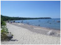
The tips, or headlands, of Methodist’s Point and Todd’s Point are battered by the prevailing wind which gathers energy over a large area of open water stretching north to Tobermory. Sand cannot settle in exposed areas and is transported in the water column leaving behind a rockier shoreline.
Between each exposed point are more protected areas which have allowed sand to settle. These areas are Awenda’s four sand beaches and wetlands. The headlands help shelter the beaches from high-energy waves. This continual process led to the formation of the entire Penetanguishene Peninsula over thousands of years.
Challenge: The answer is blowing in the wind
You don’t need a weatherman to know which way the wind blows! Take a moment to feel the breeze and look at the air photo provided. Can you tell the direction of the prevailing wind by looking at the Park’s four sand beaches?
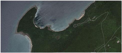
Clue: Giant’s Tomb is aligned north-south with the tip pointing north. Is the wind blowing true today?
Next Up:
To reach Stop #8, continue down (to your left if facing the water) 3rd Beach’s sandy shore till you get a good view of the whole beach. Then scan the QR code for Stop #8!
[whohit]-Stop7-[/whohit]